Map it
Map it
Map it
A global site surveying and observing platform for construction sector organizations worldwide to examine building sites for project milestones and supervise them from a distance.
A global site surveying and observing platform for construction sector organizations worldwide to examine building sites for project milestones and supervise them from a distance.
Position - UI/UX
Length - 8 Weeks
Methodology - Lean UX
Position - UI/UX
Length - 8 Weeks
Methodology - Lean UX
Position - UI/UX
Length - 8 Weeks
Methodology - Lean UX
0.1 Background
The Organization for Autonomous Vehicle Systems Worldwide foresees that drone utilization will create 100,000 employment opportunities by 2025. Both construction and engineering sectors have witnessed a consistent growth in drone adoption. Drones have enhanced the safety of the surveying process and cut down surveying time from hours to just minutes. Drone-assisted mapping enables access to locations that would be impossible to reach by foot.
0.2 Technology Research
Type of sensors used for Drone mapping.
⦁ Lidar Sensor: LIDAR (light detection and ranging) is a decades-old technology that has only recently been accessible in size and power suitable for big drones.
⦁ GPS (global positioning system) is an essential service component for geolocation.
⦁ Accelerometer: The acceleration applied to the gadget is measured.
⦁ Gyroscope: The angular speed in 3D space around all axes,
⦁ Magnetometer: The ambient magnetic field is measured in all axes
0.3 Problem Statement
Topographical surveying processes can be extensive and require substantial hands-on effort on-site. Factors like weather and natural obstacles impede efficiency. An opportunity arises to accelerate land surveying, thus improving the swiftness and effectiveness of the job.
0.3 Problem Statement
Topographical surveying processes can be extensive and require substantial hands-on effort on-site. Factors like weather and natural obstacles impede efficiency. An opportunity arises to accelerate land surveying, thus improving the swiftness and effectiveness of the job.
0.3 Problem Statement
Topographical surveying processes can be extensive and require substantial hands-on effort on-site. Factors like weather and natural obstacles impede efficiency. An opportunity arises to accelerate land surveying, thus improving the swiftness and effectiveness of the job.
0.4 Hypothesis
We assert that utilizing drones for topographical survey tasks can transform the whole terrain survey process, enabling cost-efficient, rapid, and seamless land surveying irrespective of external factors and demonstrating benefits for every organization participating in the project.
0.4 Hypothesis
We assert that utilizing drones for topographical survey tasks can transform the whole terrain survey process, enabling cost-efficient, rapid, and seamless land surveying irrespective of external factors and demonstrating benefits for every organization participating in the project.
0.4 Hypothesis
We assert that utilizing drones for topographical survey tasks can transform the whole terrain survey process, enabling cost-efficient, rapid, and seamless land surveying irrespective of external factors and demonstrating benefits for every organization participating in the project.
0.5 Design Process
The three phases of the lean UX process considered are as follows:
1. Think
2. Make
3. Check
0.5 Design Process
The three phases of the lean UX process considered are as follows:
1. Think
2. Make
3. Check

0.5 Design Process
The three phases of the lean UX process considered are as follows:
1. Think
2. Make
3. Check
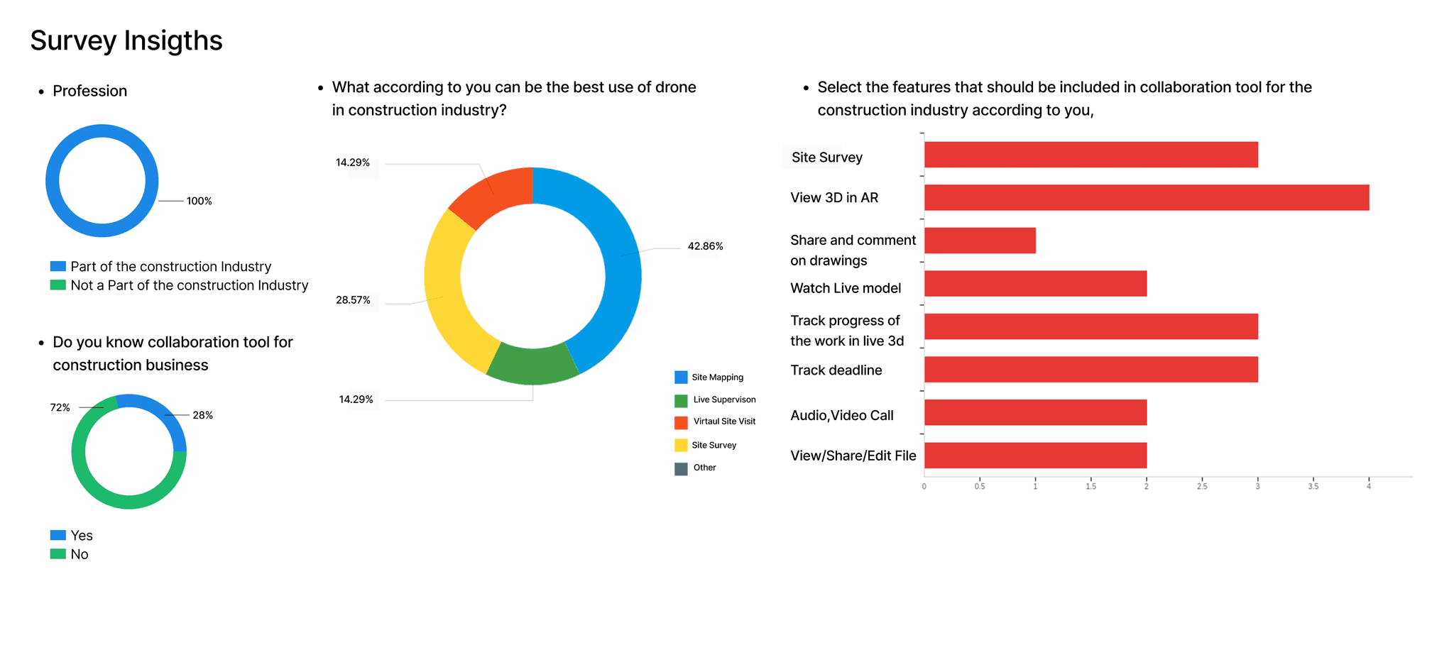
0.6 Surveys
The study was heavily focused on the basic notion of developing an application for cooperation in the construction industry. Most of the closed-ended questions focused on issues that arise in the construction industry while working with other agencies.
Key Findings
The majority of the people think using Augmented reality can be beneficial.
The majority of the people think the prominent use of drones is for mapping.
The majority of the people face problems while collaborating with other agencies.
0.7 Interviews
All the participants were chosen based on a criterion that prioritized creating a mapping and monitoring application for the construction industry, by approaching them directly. The participant recruited for the interviews were from different business groups, but all fit within the umbrella of the construction sector.
Key Findings
⦁ At this stage, the concept of collaboration application changed to the mapping and monitoring application.
⦁ The Key users were reduced as per the interview insights.
⦁ The process of mapping with the current technique and its drawbacks compared to drone mapping was discussed.
Key Issues
Have to travel to sites.
Traditional Survey time consuming.
Hard to explain drawings to unskilled workers.
Major Needs
Device to Monitor site remotely.
Device to Map construction site.
Device to explain 3d views in simple way to non technical workers.
0.8 Assumptions
In assumption mapping, three categories of assumptions were identified:
1. Desirable Assumptions To assess: Do they want this?
2. Viable Assumptions To evaluate: Should we do this?
3. Feasible Assumptions To determine: Can we do this?
0.8 Assumptions
In assumption mapping, three categories of assumptions were identified:
1. Desirable Assumptions To assess: Do they want this?
2. Viable Assumptions To evaluate: Should we do this?
3. Feasible Assumptions To determine: Can we do this?
0.8 Assumptions
In assumption mapping, three categories of assumptions were identified:
1. Desirable Assumptions To assess: Do they want this?
2. Viable Assumptions To evaluate: Should we do this?
3. Feasible Assumptions To determine: Can we do this?

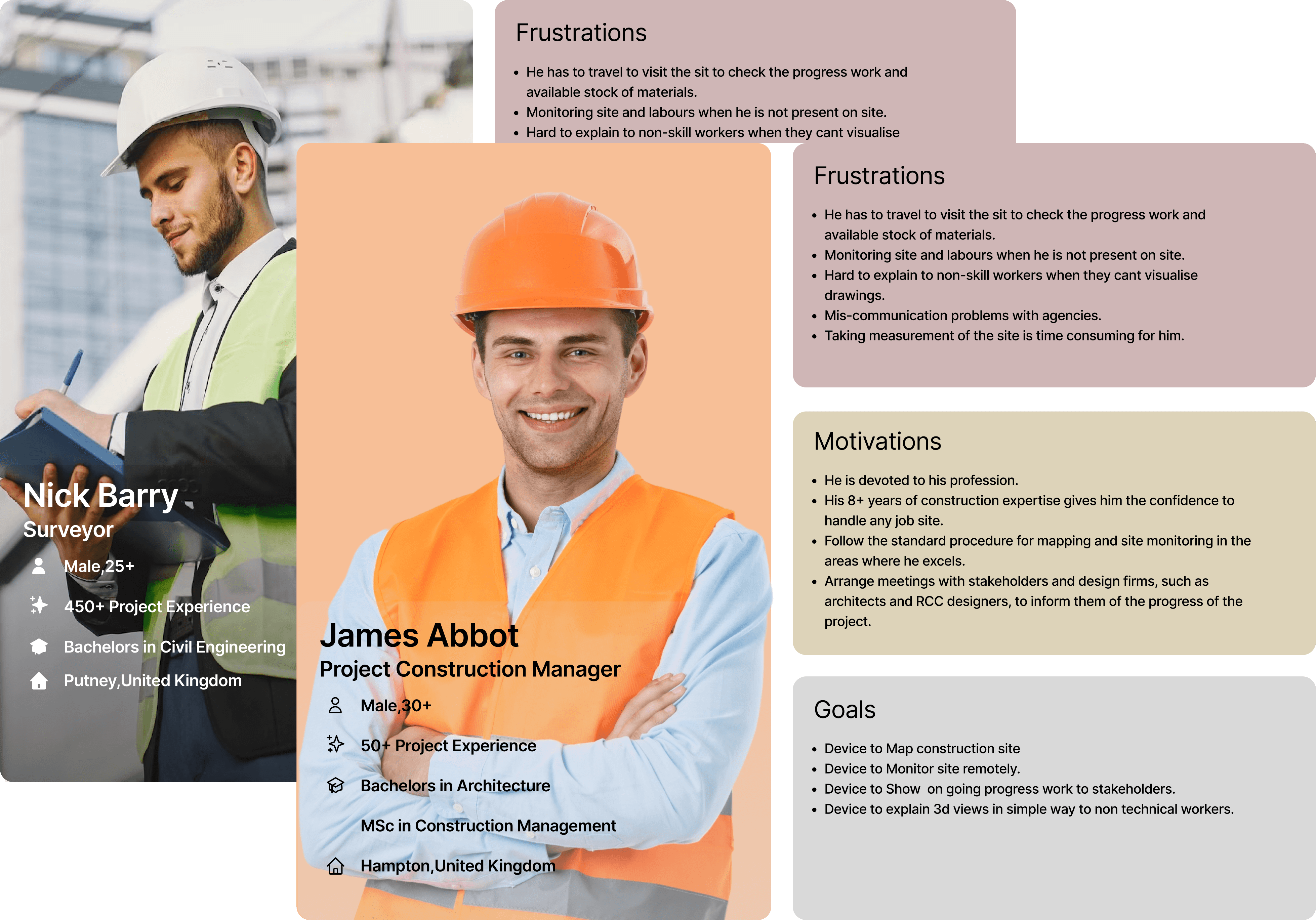
0.9 Photo Persona
Based on the assumptions, updated personas were created.
Persona 1 - James Abbot, a construction manager, emphasizes the significance of comprehensive land analysis for smart decision-making. He pursues a device that assists him in attaining an extensive and intricate understanding of the land, facilitating well-informed selections. His primary objective is to complete the surveying process seamlessly without delays.
Persona 2 - Nick Barry, a surveyor, focuses on carrying out surveys efficiently, quickly, and with minimal injuries. He prefers safety and speed over accuracy and complexity. He needs a tool that enables him to conclude surveys swiftly without compromising safety.
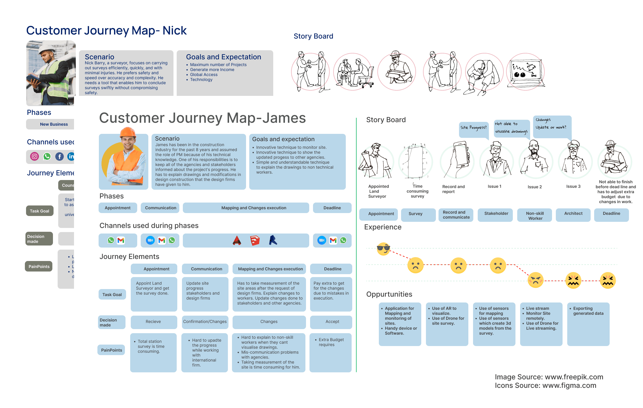
10.0Customer Journey Map
The Customer Journey Map is formed with the proto persona Motivation, Frustration, and Goals.
Key Findings-
Opportunities generated
⦁ Application for Mapping and monitoring of sites.
⦁ Handy device or Software.
⦁ Use of AR to visualize.
⦁ Use of Drone for the site survey.
⦁ Use of sensors for mapping
⦁ Use of sensors which create 3d models from the survey.
⦁ Live stream
⦁ Monitor the Site remotely.
⦁ Use of Drone for Live streaming.
⦁ Exporting generated data
11.0Ideation
Throughout this stage, remedies to the problems and requirements were created. This stage is chiefly devoted to identifying particular functions that can support the software in fulfilling the anticipations and desires of the main users.
11.0Ideation
Throughout this stage, remedies to the problems and requirements were created. This stage is chiefly devoted to identifying particular functions that can support the software in fulfilling the anticipations and desires of the main users.
11.0Ideation
Throughout this stage, remedies to the problems and requirements were created. This stage is chiefly devoted to identifying particular functions that can support the software in fulfilling the anticipations and desires of the main users.


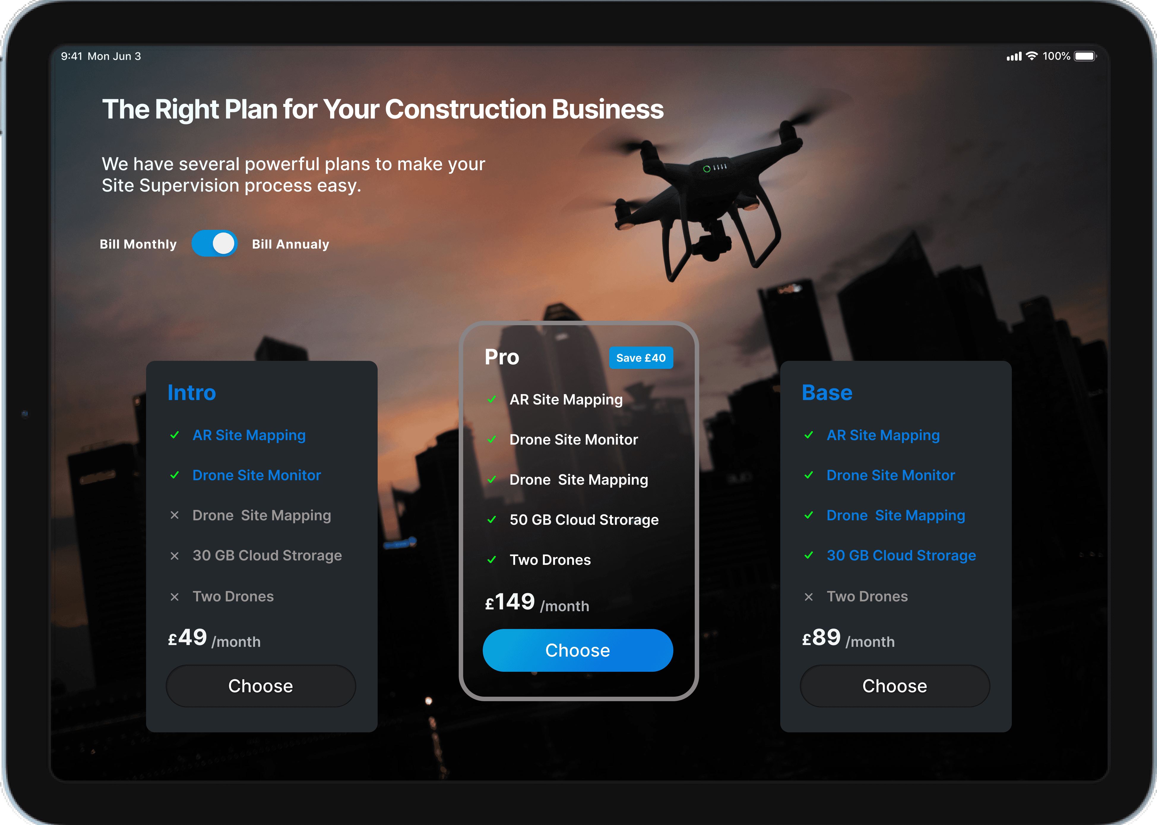
12.0Business Plan
The following areas were thought during the evolution of the process.
Subscription Plans
Intro
Base
Pro
Renting Drones
Cloud Storage
12.0Business Plan
The following areas were thought during the evolution of the process.
Subscription Plans
Intro
Base
Pro
Renting Drones
Cloud Storage
12.0Business Plan
The following areas were thought during the evolution of the process.
Subscription Plans
Intro
Base
Pro
Renting Drones
Cloud Storage
13.0Site Map
The sitemap assisted in the product's development, removal of unneeded functionalities, recognition of visual hierarchy, and creation of user-focused navigation. The app's pages and progression are illustrated in the hierarchical diagram, contributing to design choices.
13.0Site Map
The sitemap assisted in the product's development, removal of unneeded functionalities, recognition of visual hierarchy, and creation of user-focused navigation. The app's pages and progression are illustrated in the hierarchical diagram, contributing to design choices.
13.0Site Map
The sitemap assisted in the product's development, removal of unneeded functionalities, recognition of visual hierarchy, and creation of user-focused navigation. The app's pages and progression are illustrated in the hierarchical diagram, contributing to design choices.

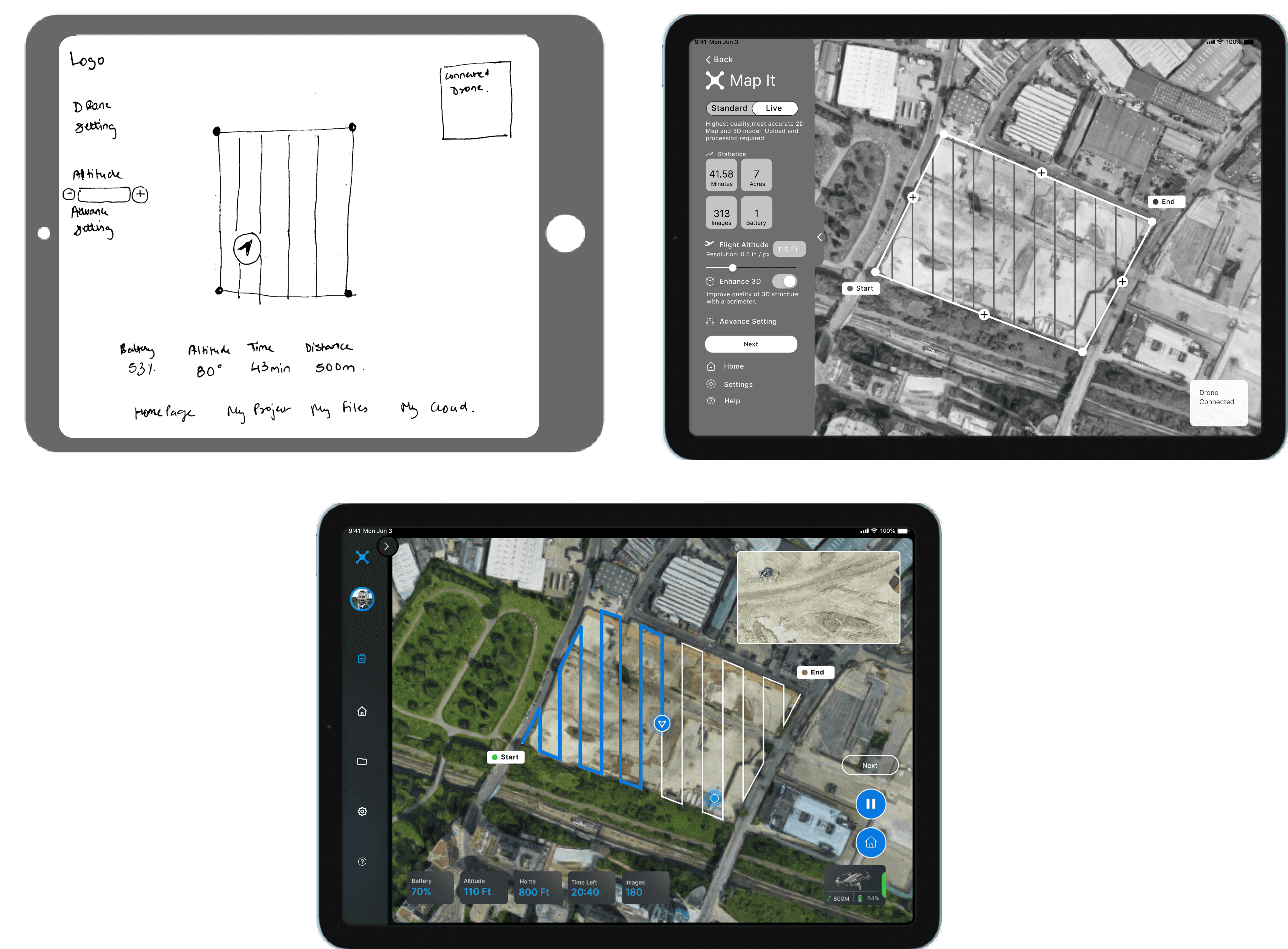
14.0Prototype
Validated learning, which refers to visible (and valued) reactions from intended consumers that shape the design, is one of the fundamental principles of the lean start-up technique. Minimal paper prototypes were created for all of the main elements that would lead to the completion of the user actions, as suggested by the Lean UX approach before Mid-fi and High-Fi prototype.
15.0Final Screens
15.0Final Screens
Home Page
Shows all projects details
Streaming
Shows all the live construction site streaming with viewers and pilot.
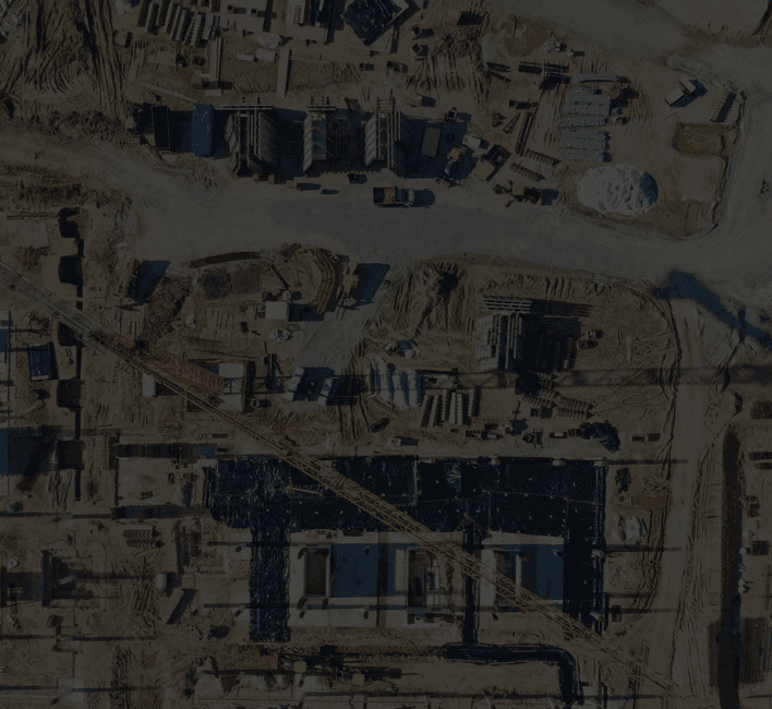
Survey
Shows the interface while drone is surveying the area marked.
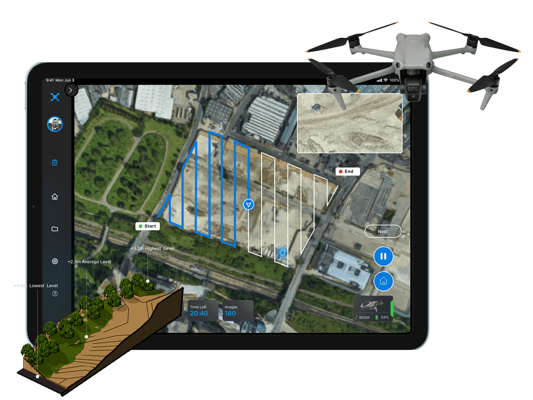
Planning Flight
Shows the interface while pilot is planning a flight.
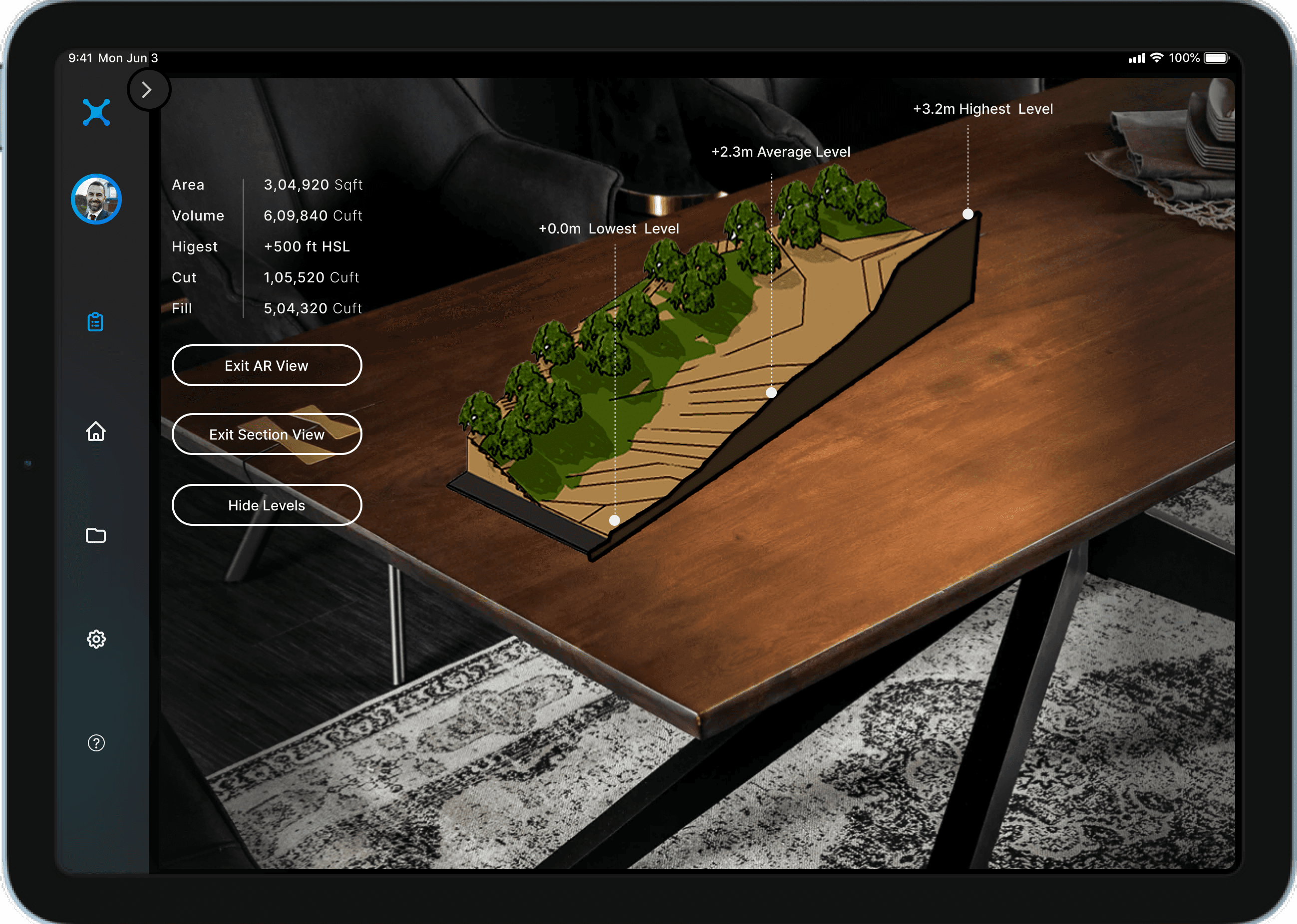
Survey Report
Shows the Survey results in 3D.
Geo-AR
Shows the 3d model imported in live environment using Augmented reality
Home Page
Shows all projects details
Streaming
Shows all the live construction site streaming with viewers and pilot.
Survey
Shows the interface while drone is surveying the area marked.
Planning Flight
Shows the interface while pilot is planning a flight.
Survey Report
Shows the Survey results in 3D.
Geo-AR
Shows the 3d model imported in live environment using Augmented reality
16.0Testing
The application's complexity necessitated the usage valence test methodology. The participants were told to think aloud and proclaim green if everything appeared to be in order and red if something appeared to be missing while doing the task. The participants' flow as well as their recommendations were recorded.
Key Findings
⦁ 4 out of 5 found the application easy.
⦁ 1 out of 5 had problems with the pop-up screen background.
⦁ 3 out of 5 Appreciate the Augmented reality Screens.
⦁ 1 out of 5 got confused while choosing the subscription plan due to the interface.
⦁ 1 out of 5 suggested adding an extra screen for the Tutorial to see the application complexity.
17.0Discussion
Strength -Mapit allows for mapping oversight from afar.The Mapit user interface is superior to those of other programmes. Mapit provides cloud storage as part of its membership plan. The Mapit app allows users to retrieve their data independently. The app can stand out by combining Geo-AR with GPS technology, which is a significant aspect of UAV technology. At the stroke of a button, Mapit users may see and retrieve all deliverables. Users may keep track of all ongoing projects on the Mapit application's home page. The Mapit application's ability to collaborate with other agencies by simply adding them to the project group is a critical success factor.
Limitation- Because Mapit rents the drone with Lidar technology, the data precision, which is a problem in other applications, can be solved. Although the Mapit does not now provide any training courses, they may be added to the future work section. Because the MVP prototype does not allow for real testing, the application's genuine working prototype should be tested in usability testing to gain a better understanding of the technology necessary and whether the technology currently in use is enough or should be altered.
15.0Final Screens
17.0Discussion
Strength -Mapit allows for mapping oversight from afar.The Mapit user interface is superior to those of other programmes. Mapit provides cloud storage as part of its membership plan. The Mapit app allows users to retrieve their data independently. The app can stand out by combining Geo-AR with GPS technology, which is a significant aspect of UAV technology. At the stroke of a button, Mapit users may see and retrieve all deliverables. Users may keep track of all ongoing projects on the Mapit application's home page. The Mapit application's ability to collaborate with other agencies by simply adding them to the project group is a critical success factor.
Limitation- Because Mapit rents the drone with Lidar technology, the data precision, which is a problem in other applications, can be solved. Although the Mapit does not now provide any training courses, they may be added to the future work section. Because the MVP prototype does not allow for real testing, the application's genuine working prototype should be tested in usability testing to gain a better understanding of the technology necessary and whether the technology currently in use is enough or should be altered.
Home Page
Shows all projects details
Streaming
Shows all the live construction site streaming with viewers and pilot.
Survey
Shows the interface while drone is surveying the area marked.
Planning Flight
Shows the interface while pilot is planning a flight.
Survey Report
Shows the Survey results in 3D.
Geo-AR
Shows the 3d model imported in live environment using Augmented reality
16.0Testing
The application's complexity necessitated the usage valence test methodology. The participants were told to think aloud and proclaim green if everything appeared to be in order and red if something appeared to be missing while doing the task. The participants' flow as well as their recommendations were recorded.
Key Findings
⦁ 4 out of 5 found the application easy.
⦁ 1 out of 5 had problems with the pop-up screen background.
⦁ 3 out of 5 Appreciate the Augmented reality Screens.
⦁ 1 out of 5 got confused while choosing the subscription plan due to the interface.
⦁ 1 out of 5 suggested adding an extra screen for the Tutorial to see the application complexity.
17.0Discussion
Strength -Mapit allows for mapping oversight from afar.The Mapit user interface is superior to those of other programmes. Mapit provides cloud storage as part of its membership plan. The Mapit app allows users to retrieve their data independently. The app can stand out by combining Geo-AR with GPS technology, which is a significant aspect of UAV technology. At the stroke of a button, Mapit users may see and retrieve all deliverables. Users may keep track of all ongoing projects on the Mapit application's home page. The Mapit application's ability to collaborate with other agencies by simply adding them to the project group is a critical success factor.
Limitation- Because Mapit rents the drone with Lidar technology, the data precision, which is a problem in other applications, can be solved. Although the Mapit does not now provide any training courses, they may be added to the future work section. Because the MVP prototype does not allow for real testing, the application's genuine working prototype should be tested in usability testing to gain a better understanding of the technology necessary and whether the technology currently in use is enough or should be altered.
More Projects
More Projects
More Projects
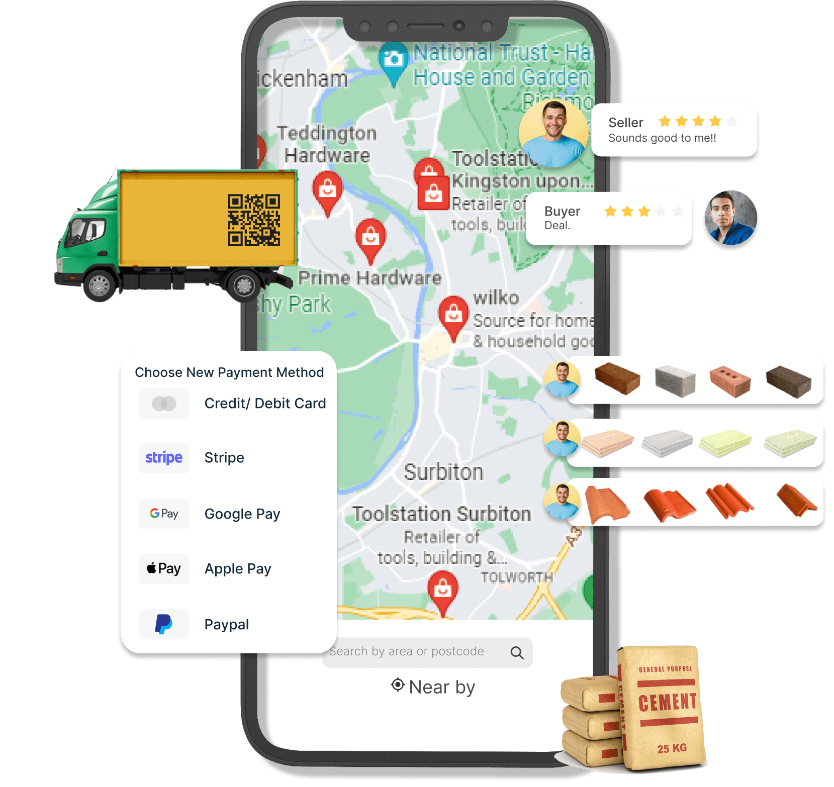
Vencart
Vencart
A e-commerce marketplace application that allows individuals and construction companies to remotely bargain with construction materials suppliers across the United Kingdom based on their specific requirements.
A e-commerce marketplace application that allows individuals and construction companies to remotely bargain with construction materials suppliers across the United Kingdom based on their specific requirements.